As we stated before, according to the Common Ground Alliance (CGA), over the last 20 years, improperly located or unlocated subsurface utilities have caused $1.7 billion in damages and resulted in thousands of injuries and hundreds of fatalities.
Most – if not all – of these losses could have been avoided through a detailed site investigation using multiple technologies and highly trained personnel.
In part one of SIM explained, we previously gave a larger overview of what SIM is and the thought behind the methodology. In part two, we will cover a few of the different most common utility locating and concrete scanning methodologies as well as where SIM is most likely to expand.
Understanding Two Vital Subsurface Scanning Techniques
Understanding the two primary technologies of SIM is a requirement of the field technician. These technologies are ground penetrating radar and EM locating.
Ground Penetrating Radar
GPR facilitates the location of utilities, the detection of leaks, and many other applications.
GPR is composed of three main components. It has three parts: a transmitter, a receiver, and a control unit.
Various forms of GPR equipment exist, but its function remains the same. A transmitter transmits electromagnetic waves of a specific frequency into the ground through the antenna. The electromagnetic waves are reflected up to the antenna receiver with different travel times and intensities (amplitudes). Afterward, this information is encoded and sent to the control unit, which then produces a visual image on the display.
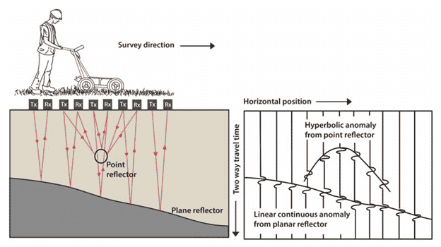
Electrical conductivity, transmitting frequency, and radiated power determine the effective range of ground penetrating radar. Although higher frequencies provide greater resolution, they can’t penetrate as deep into the ground as lower frequencies. Conductive ground is more difficult for electromagnetic waves to penetrate. This is because of attenuation. As a result, electromagnetic waves usually produce images with a low level of detail or resolution. Different ground materials can significantly affect the image produced. Ground penetrating radar (GPR) is commonly used to make images of the ground within five to ten feet of the surface. GPR imaging of ice can penetrate as deep as hundreds of feet, whereas images of dry sand and concrete may reach 20 feet, and wet soils such as clay may only penetrate a few inches.
Electromagnetic Locating
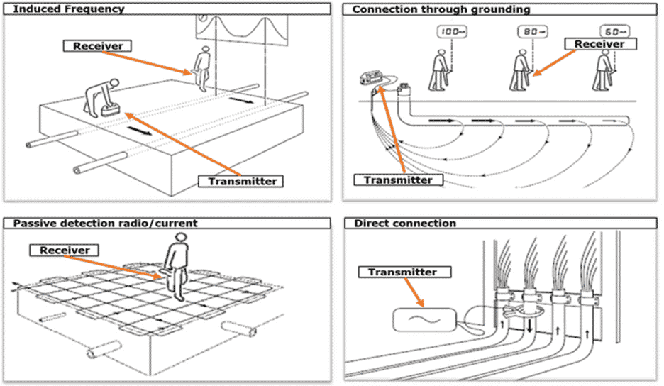
Electromagnetic locating, also known as EM locating, is another primary method of nondestructive subsurface locating. Electromagnetic locating can be either active or passive.
Active Locating
Active locating involves actively transmitting a frequency through the underground utility’s conductive material. This is done by connecting through various points depending on the utility. The transmitter can be connected to water pipes using a riser, hydrant, or valve. Electric or telephone signals are generally applied to a cable system by grounding with the utility’s grounding structure. Power lines can be located by connecting a meter box, a transformer, or a ground wire. You can identify telephone and cable television systems by applying a signal to the ground cables in pedestals, manholes, or interface boxes.
The electromagnetic field is then detected by waving a wand over the ground. A field technician records the location of detected waves, indicating or mapping the path of the subsurface utilities.
Active locating can be accomplished in one of two ways: direct connection and induction. Direct connection is when a transmitter is connected to a line, and another lead is connected to the ground. Then the receiver is set to the same frequency, which translates that signal into the control unit.

However, this type of active locating is only available if the technician directly has access to the utility. The induction method of locating is when the technician applies a clamp that transmits an electromagnetic wave signal through the surrounding utilities and lines. Induction using a ring clamp induces signals onto metallic cables or conduits where direct connection is not possible. A transmitter broadcasts a radio frequency over a large area near the target conductor. Due to this, the transmitter will transmit through anything around it, not just the intended utility. Additionally, due to the amount of electromagnetic coupling or bleed-off created, induction can be less desirable. Regardless, the induction method is an invaluable locate method when used correctly.
EM locating is relatively unaffected by the ground’s composition. EM locating can work in various conditions, including soil, clay, or water. It is a very effective method of locating utilities in less-than-ideal conditions, including inside buildings or congested areas.
Passive Locating
A field is detected traveling along a utility from an unapplied source such as active power or radio waves in passive utility locating. Water, natural gas, steam, cable television, and copper telephone lines are utilities that can carry passive signals. Using these frequencies is often less reliable, so active locating is always recommended.
Due to the current flowing through the cables in the USA, an electromagnetic field is generated at 60Hz. Such fields can be detected using passive locating techniques. Locating underground power lines using this method is sometimes used by utility locators since it is easier and faster than connecting directly to the utility. SIM-certified Project Managers know when to use passive locating versus active locating to get the most accurate results.
It is essential to have an industry standard for utility locators. Some construction firms require utility locators to be SIM certified to maintain an overall standard of quality and procedure.
The Future of SIM Specification
SIM is dedicated to providing the subsurface damage prevention industry with high-quality standards and specifications. Through these specifications, we can make the industry safer and more productive. While creating these specifications is difficult and promoting adoption can be challenging, we’re confident that SIM will significantly aid the industry over time.
In the future, we can expect to see more specifications for other subsurface damage prevention industries such as CCTV Video Pipe Inspection, leak detection, and possibly even mapping and modeling services.
Schedule a Project Today
GPRS specializes in ground penetrating radar, video pipe inspection, and mapping and modeling services. Our Project Managers have the equipment and expertise to handle all subsurface challenges presented. GPRS does this by utilizing various equipment paired with their industry-leading SIM process.
So don’t wait. Click here to schedule a project with GPRS and allow our highly trained Project Managers to keep your projects on time, on budget, and safe.